It was a beautiful morning so we decided to take the hike to the top of Buffalo Mountain again. When we hiked up Buffalo Mountain several weeks ago, Ann never got to the summit because one of the girls from the Dominican Republic had some breathing problems and couldn't continue, so Ann stayed behind with her. Time for her to see what she missed on the first hike.
On our way to the top, we found a new wildflower, common evening primrose, that was in bloom everywhere along the bottom of the trail.
About halfway up the mountain, we found this unique trail marker carved out of a tree stump. No idea who did this creative wood carving.
We reached the summit after hiking for about 45 minutes along the narrow steep trail with 6 switchbacks, needing to stop a few times to catch our breath. The views were even more spectacular in the middle of the day than at sunset during our last hike.
Paul with North Carolina in the background.
Paul is shown below hiking the final 20 yards to the very top of the mountain.
Paul at the very top, 3971 ft. above sea level, looking north over Virginia.
This hike, while only about a mile long each way, is very strenuous because of the rapid gain in elevation. The cool breezes at the summit as well as the great views make this hike one of the more memorable hikes we have taken here in Virginia.
Ann's sister, Kathy, lives in Bristol, Tennessee, about 90 miles west of Hillsville. Kathy recommended several hikes in Grayson Highlands State Park, about a 90 minute drive west of Hillsville on a very curvy and up and down two lane road. As we drove into the park we were greeted by some fabulous views of the mountains and rolling hillsides.
We started out by hiking the Rhododendron Trail which leads to a herd of wild ponies. As we began this hike with the temperature in the 70's, we saw this sign. Little did we know just how true it would be.
The hike wound up an open field past many rhododendron bushes which had bloomed a few weeks prior to our arrival. After a half mile, we came across this sign.
We were now walking along the Appalachian Trail, the famous marked hiking trail over 2,200 miles long extending from Georgia to Maine. As we continued up the mountain, we began to watch the darkening clouds very closely.
We didn't get much past the AT sign before the rain began. After putting on ponchos, we continued our trek to see the wild ponies, now visible about 600 yards away. The rain became heavier, and we could see the rain driving the ponies to seek some form of shelter. Since our objective of getting close to the ponies wasn't going to be achieved, we headed back down the trail. Smart move, as we found out.
Not many wildflowers on the mountain, but we did find a few stalks of Grey Beardtongue.
We sat on the porch of the visitors' center to enjoy lunch on the only two rocking chairs that were not drenched by the pouring rain, as the thunder boomed across the mountains and echoed in the valleys. The temperature now was closer to 60 degrees. We were glad that we were high and dry and off the trail, as we saw many soaked park visitors running into the center to seek shelter from the storm.
The rain wasn't going to stop any time soon, so we headed out of the park. We again stopped to see the changing view, now observing that we were above some of the clouds left over from the storm.
The drive back down the curvy road was challenging, as we were now driving through the clouds we observed from above. Once we reached the bottom of the mountain, we headed south along some rural roads to West Jefferson, NC. Yes, you guessed it. It was time for the June beer dinner at Boonedock's.
We enjoy trying different foods as well as sampling new beers. This beer dinner was sponsored by Sierra Nevada Brewing Company, which has just completed building a brewery in Asheville, NC.
As we were gathering for dinner seating, we were first served a sample glass of their flagship beer, Sierra Nevada Pale Ale, readily available in grocery stores. Still tasted good on draft.
Our first course was a cucumber cilantro bisque, served cold, which was paired with Summerfest German Lager. This beer was a lighter variety, similar to a summer ale. Paul is not a huge cucumber fan but he sipped over half of this shot glass before deciding that he had enough.
As you look at each course, notice how the beer gets darker in color
as the meal progressed. The darker colored beers are made with barley
that is roasted longer.
The appetizer was a southwestern eggroll paired with Single Hop 291. This beer tasted similar to many of the good IPA's we have enjoyed since coming to Virginia. The eggroll was spicy but very flavorful.
The main course was a pork chimichanga, paired with Southern Hemisphere Fresh Hop. This was another good hoppy beer which was slightly darker in color but very rich in hoppy flavor. The chimichanga was stuffed with Ashe County Cheddar, onions, peppers and rice.. Boondock's tries to use as many fresh local ingredients as possible.
Dessert was a cilantro-lime cheese pastry served with a Rain Check Spiced Stout. This is Sierra Nevada's first beer originating in North Carolina, meaning this beer has not ever been made in California, their home location. While we are not fans of real dark beers, as we slowly sipped this beer, we could tell that the flavor of the beer complimented the dessert. Cheddar.
What could be better than a day enjoying the fresh air in the out-of-doors followed by good food and good beer?
The weather forecast was iffy so we decided to explore some of the historical sites of this area. We started out at Shot Tower about 20 miles north of Hillsville.
Shot Tower Historical State Park is perhaps one of the smallest state parks in any state, probably no bigger than an acre. It took over five years to build the Jackson Ferry Shot Tower, being completed in 1807. Shot was a small metal ball that was fired from a musket; a forerunner of a bullet.
Workers would hoist the pieces of lead to the top of the tower using a pulley system with livestock pulling the lead to the top. The lead was smelted and poured into giant sizing sieves to make the different sizes of shot needed. The lead then free fell through the tower into a kettle of water at the bottom which acted as a cushion to prevent the shot from losing its round shape.
For over 30 years the Jackson Ferry Shot Tower manufactured ammunition for a growing nation. Normally, shot towers were 150 in height, the height necessary to form a perfectly round ball. By building this shot tower on a cliff, the tower only had to be 75 feet in height with the remainder of the necessary distance made up from the height of the cliff down towards the New River. The workers would get to the base of the shaft through a tunnel into the side of the cliff. Pretty ingenious design!
Just north of Shot Tower is what remains of the town of Foster Falls. Foster Falls was once a bustling town in the late 1800's and into the early 1900's, known for its iron industry. In 1895 the population was 296. Below is a grist mill and corn crib.
The general store sold all the necessities the residents needed that they couldn't grow or raise for themselves.
The iron furnace was constructed in 1881 and stayed in operation until 1914. The railroad came soon after the iron furnace was built to transport the iron to the major cities in the east and midwest. You can see how tall this furnace is when you compare its height to Paul who is 6 ft. 1 inch. This furnace produced 12 tons of pig iron per day.
Dozens of iron furnaces and forges dotted the New River Valley due to its high mineral content. In 1887, the railroad built a dinky rail bridge across the river to the hematite ore mines located a 1/4 mile above the Foster Falls station. This is all that remains of this bridge which was washed out by flooding in 1916.
Here is the railroad station as it looks today. It serves as the New River State Park office and store at Foster Falls.
This very well preserved caboose sits next to the train station.
Across from the train station is this once stately hotel, built in 1895 to house railroad passengers. It is being restored today into a bed and breakfast inn.
As we began our hike towards Shot Tower, there were sheer cliffs on both sides of the river. These cliffs shown below are on the opposite side of the river from where the train tracks were.
Sometimes the cliffs were right next to the train tracks. You can see the hiking path where the train tracks were at the bottom of this photo.
When the railroad was built, the workers sometimes had to cut through the rocky hillside to lay the level track bed. If you look closely you can see about a 8 ft. high rock on the left as the track was cut through with the sheer cliff on the right. Historic rumors suggest that these passageways were cut through the rock by men using pick axes and very few explosive charges.
Occasionally there was a tree which appeared to be growing right out of the rocky hillside. Look just above the yellow arrow in the photo below.
We breathed in the strong sweet smell of honeysuckle as we passed many honeysuckle bushes all along our hike.
We arrived at the part of the trail below Shot Tower. Here is a view looking upward.
We continue to be amazed at many of the colorful flowers we see blooming during our hikes. Most notable during our hike from Foster Falls to Shot Tower were
Crown Vetch
Dense Blazing Star
Chicory
Morning glory
Almost more amazing were the colorful butterflies that would continue to flutter about all during this hike. Ann was able to get this photo of a small blue butterfly after many attempts. The butterflies just wouldn't stay still long enough for a good photo.
While this hike was not strenuous on our bodies, it was enlightening to see the history that took place in this part of Virginia. The early settlers definitely used great ingenuity to accomplish the tasks that needed to be done to not only build places to live but to be able to exist in sometimes difficult times due to harsh weather and other obstacles.
One of our younger coworkers asked us to go on a hike after work, knowing that we enjoy hiking. At about 7 PM, we began our travel to the trail by driving back country roads, up and down and up and down hills and around curve after curve. We know understand why Hillsville got its name. We drove approximately 40 minutes to Buffalo Mountain Natural Area Preserve. We have never done an evening hike before, and we were told to bring flashlights. A new type of adventure!
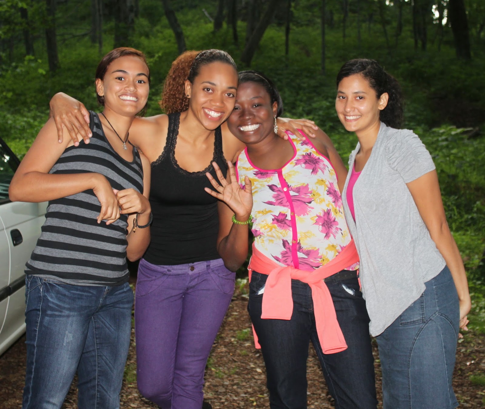
Our younger coworkers were poised and ready to go. From left to right: Jake, Hannah, Madeline, Rosa, Eunike, and Mabeli. Jack is an engineering student at Va Tech, Hannah is a senior at the local high school, and the other four girls are from the Dominican Republic.
Here is a close-up of the girls from the Dominican Republic, who came to the U.S. on J-1 visas. This type of visa permits them to work in the US for a short period of time. The exchange visitor (J) non-immigrant visa category is for individuals approved to participate in work-based exchange programs.
We hiked up a steep and narrow trail that included many switch-backs, too numerous to count. There were several benches along the way. Rosa rests with Madeline and Hannah.
After about 40 minutes of hiking upward a little over a mile, we reached the summit of Buffalo Mountain at 3971 feet above sea level. Madeline, Mabeli, and Rosa posed for a summit photo with North Carolina in the background.
Here is a group photo with some North Carolina mountains in the background. We were unable to stand closer together because of the rough terrain at our feet.
Hannah took this panorama photo with her iPhone. The Adirondack Mountains are in the distance. Isn't technology wonderful?
Since the sun had set, the hike down began in partial darkness. The photo below shows the blueness of these picturesque mountains at dusk.
The mountain was so shady that we were surprised by finding these flowers, gorgeous bright orange azalea rhododendrons, near the top of the mountain. You can tell how dark it was getting as we hiked back down the mountain.
We concluded our hike using flashlights for the last quarter mile. This was our first sunset hike and proved to be a great new adventure. The views from the summit were spectacular. It was very enjoyable to spend time with these young workers as we found fun together away from the workplace.
It was time to venture into nearby North Carolina to do some hiking. We decided on Hanging Rock State Park, partly because of the reviews we were able to read online and also for its proximity to Winston-Salem, NC, where we could shop at a Trader Joe's for the first time in 6 weeks.
The drive down to Hanging Rock State Park was along winding rural Virginia and North Carolina roads mostly downward from the Blue Ridge Mountains. We passed through small, remote towns along the way, observing that folks in these towns shopped at general stores, not grocery stores. The last portion of our drive was back up in elevation as we climbed into the Sauratown Mountains from the nearby countryside. Most of what remains of these ancient mountains is erosion-resistant quartzite which supports Hanging Rock and other scenic ridges and knobs. Hanging Rock is approximately 2150 feet above sea level. Nothing majestic like the Tetons but a great view anyway.
Between 250 and 500 million years ago, this land was pushed up as the continents moved towards each other, as the older, harder rocks were pushed up and over younger, softer rocks. Weather and erosion have given the ridge its distinctive shape.
We began our hiking with a short walk to the Rock Garden, which really shows the quartzite rocks as they have been preserved by nature. You can get an idea of just how big these rocks are if you look at how the rock towers over Paul, who is 6 ft. 1 inch tall.
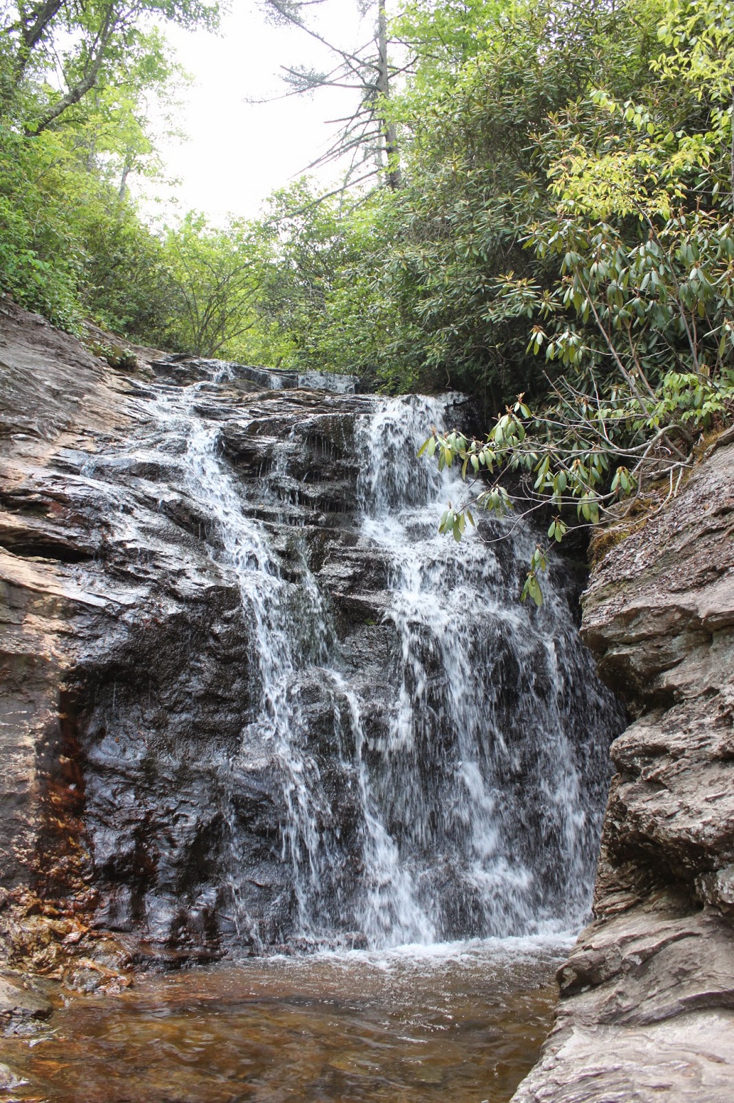
After leaving the Rock Garden, we headed downward along a crushed rock trail to Upper Cascades Falls. There were several switchbacks along the trail until we came upon this view of the falls. Paul felt the water in the pool at the base of the falls, and it wasn't as cold as the snow melt we encountered in Wyoming.
The climb back up this trail gave us a cardio workout that we haven't experienced since hiking in the White Mountains of New Hampshire last summer.
The next trail we took was the Indian Creek Trail, leading us to two more waterfalls. The beginning of this trail was a slow downward walk - easy hiking. Then the trail got narrower and more downward in slope, with many stair drops created using timbers to hold the soil and crushed rock in place. Window Falls awaited us with this view.
It is easy to see why it is called Window Falls. Notice the young couple sitting in the "window" admiring the falls from this vantage point. These people are looking at the falls sideways and below them.
We continued our hike down to Hidden Falls. The last 1/8 of a mile of this trail was over steep stone steps leading down to the falls itself.
Is Paul admiring Hidden Falls or contemplating the steep upward hike back up the trail?
We passed this tree that appeared to be growing out of the side of this huge rock.
The hike back up tested our endurance as we climbed up the trail for over a mile to get to our car. The temperature had climbed into the 80's by the time we finished our hiking, not hot by Florida standards. However, we were not used to the warmer temperatures since we are living at 2,500 feet in the Virginia hills, where we have been experiencing high temperatures only in the 70's.
Why no flower pictures? We didn't see any flowers in bloom, which we attribute to all the shade along the hiking paths
The views of the three cascading waterfalls and the Piedmont Plateau brings back memories of some of the hikes we enjoyed in the Tetons several years ago and reinforced why we wanted to spend our summer in a more mountainous area of the country.


 .
.